Jøkullaup from Flatbreen
Flatbreen glacier with the mighty terminal moraine in 2007. Photo: Gaute Dvergsdal Bøyum.
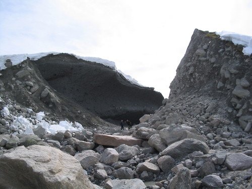
The opening in the moraine ridge 11.05.2004. Photo: Anders Jarle Muldsvor, NVE.
A jökullaup is an abrupt draining of a wide body of water. In May 2004, there was a jøkullaup from Flatbreen, which developed into a debris flow.
More than 50,000 m3 of water breaks out through the moraine ridge in front of Flatbreen Glacier at around 1000 m above sea level and flows down Tverrdalen valley, a tributary valley to Supphelledalen valley in Fjærland. Rocks, gravel and clay are swept away by the water rushing at 50 km/h down the mountainside. Green fields and farmland in Supphelledalen valley are quickly covered with clay and sand, and rocks and wood are scattered everywhere.
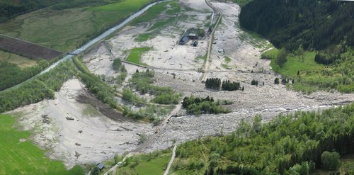
Boulders and other coarse material end up in a 75,000 m2 rock fan, while finer material and water flows over the green fields in Supphelledalen and follows the river towards the fjord. 250,000 m2 of farmland is flooded and covered with 125,000 m3 of fine material. 1 km from the rock fan, the mud layer is up to 50 cm thick.
What happened?
The rock fan that was deposited by the debris flow. Photo: Krister Kristensen, NGI.
The event occurred after days of unusually high temperatures for the time of year, which led to a large amount of snow melting. Normally, drainage channels are formed under the glacier during the spring so that the meltwater from the glacier drains down towards the regenerated part of the Supphellebreen Glacier further into the valley.
On this day, May 8, 2004, the drainage channels were not large enough. As a result, the meltwater was not drained to Supphelledalen valley, but collected under the glacier and in the lake in front of the glacier at around 1000 meters above sea level. This is dammed by Flatbreen on one side and a large moraine ridge formed during the "little ice age" (1750) on the other. The moraine ridge is 650 m long and between 25 and 50 m high. The moraine ridge had a weak point - an old opening in the moraine that was partially closed during the glacier advance in the 1990s.
Eventually, the weak point in the moraine ridge gave way and a 35 m wide and 15 m deep V-shaped trench was excavated, which led to a rapid draining of the lake. Such sudden draining of glacier dammed lakes is called a jøkullaup. The volume of water that was drained from the lake itself has been calculated at around 50,000 m3, but a similar amount of water may also have been stored in and under the glacier. Around 25,000 m3 of the moraine ridge was eroded away in the incident.
The road between Øygard and Supphella 14.05.2004. Photo: Hallgeir Elvehøy, NVE.
The view down Supphelledalen valley after the landslide. Photo: Norwegian Glacier Museum
Debris flow
The debris flow ravine in 2007. Photo: Anders Elverhøi, UiO.
The water and masses from the moraine flowed towards Tverrdalen valley, a tributary valley to Supphelledalen valley. First over a relatively flat area, then just past Flatbrehytta, and then down a steep mountain slope with bare rock. Just below the mountain slope, at around 600 meters above sea level, the flood hit a thicker layer of sediments and began to erode. More and more material was dragged along by the water masses.
The erosion path was 50 m at its widest and 8 m at its deepest. The flood developed into a debris flow and the original 25,000 m3 of sediment from the moraine grew to 240,000 m3 on the road. According to eyewitnesses, the debris flow came down towards Supphelledalen valley at a speed of around 50 km/h and appeared as a 10 m high wave with a steep front of large boulders.
Where Tverrdalen valley meets Supphelledalen valley, the terrain flattens out. A large rock fan was deposited here, about 3 km from, and 1000 m lower than where the event initiated in the moraine ridge. The fan covers an area of 75,000 m2, is 420 m long and 300 m wide. The thickness of the deposit was up to 5 m in the central area, and the volume is estimated to be 105,000 m3. The impressive rock fan ran across the road in Supphelledalen valley and covered the former parking lot, which has been a popular starting point for hiking and glacier hiking.
This happened in May, at a time and place when the area is heavily used by hikers. There were people at Flatbrehytta, and on the hillside on the north side of Tverrdøla, and people drove past down in the valley just before the landslide hit. Incredibly, no one, neither people nor animals, were injured and no cars were parked in the former parking lot that was covered by the rock fan. The agricultural area that was flooded and the hiking trail up to Flatbrehytta were actually the hardest hit.
Sources: Breien, H. 2005. On the dynamics of debris flows. Master thesis UiO.
Want to know more about jøkullaup and debris flow? Get in touch with post@glacier.museum.no


